The area of Low Hall, Walthamstow, is known to many as the home of a sports ground, nursery school, allotments, the fabulous Pump House Museum, and for the less salubrious South Access Road Household Waste and Recycling Centre. The name Low Hall, however, harks back to a much earlier site with a long and fascinating history.
The manor of Low Hall was previously known as Bedyke, named after its owner Adam de Bedyk, the King’s tailor, who is known to have been in possession of the land in 1285. In the 14th century the Lord of the Manor was city merchant and twice Lord Mayor of London, Simon Fraunceys, and the manor became known as Walthamstow Frances (or Fraunceys). Other illustrious Lords of the manor have included the Earls of Warwick, amongst them Thomas de Beauchamp the 11th Earl of Warwick, and Richard Neville, 16th Earl of Warwick, popularly known as the Kingmaker.

Between 1541 and 1560 the manor was leased to Hackney-born Ralph Sadler who became a Gentleman of the King’s Privy Chamber, and who many have been part of the household of Thomas Cromwell in his early years. The manor was subsequently purchased by the wealthy landowning Argall family and it remained with them until 1741. Perhaps the most notorious member of the Argall family to become Lord of the Manor was adventurer and sailor Sir Samuel Argall. He was employed by the Virginia Company of London in the early 17th century to defend British colonists in North America against the French. He was also responsible for the abduction and ransom of the Native American Powhatan woman Amonute (also known as Matoaka, and nicknamed Pocahontas), and he was known for his harsh rule as deputy Governor of Virginia between 1617 and 1619.
In 1741 the Manor was purchased by Huguenot merchant Samuel Bosanquet who had links with the slave trade; his son, also named Samuel, was a prosperous merchant who was handsomely compensated when the slave trade was abolished.

The Low Hall estate had been a farm for some time, and perhaps not unsurprisingly, was known as Low Hall Farm. It was purchased from the Bosanquets in 1875 by the Walthamstow Local Board, who subsequently built sewerage outfall works, and enlarged the Dagenham Brook. A resident farmer was employed by the Board (later by the Walthamstow Urban District Council who came into being in 1894), and in the later 19th and into the 20th century crops grown and sold included mangelwurzels, rye grass, mangolds, cabbages and cauliflowers. The farm was sometimes referred to as the Irrigation Farm.

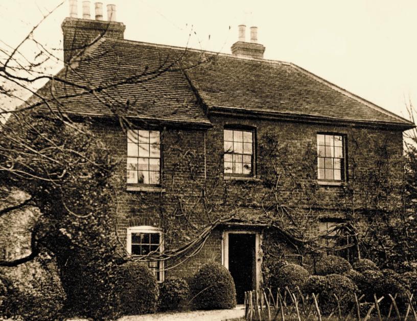
As for the manor house itself, there are two known incarnations. A later medieval moated manor house dated from the 14th century, and was located at the end of Low Hall Lane, not far from the Pump House Museum. It was a typical hall house, with a main hall, upper chamber and service range. It was later extended with a second wing, and a gatehouse was added to the existing bridge. In the 17th century the building fell into disuse and was demolished, its stone rubble apparently stolen by locals, probably to use as building materials. A two-storey timber-framed brick-fronted farmhouse was built in its place. This house stood for three hundred years or so before being destroyed along with remaining farm buildings by a V1 flying bomb in August 1944.

The site of the moated medieval manor house and the smaller post-medieval farmhouse complex was excavated in the 1990s by Museum of London Archaeology (See Ian Blair (2002) ‘A moated manor at Low Hall, Walthamstow’ in Essex Archaeology and History Volume 33, pp. 191-220, and hobleysheroes.co.uk/thethreewisemenofgotham).
And for the curious who are wondering…yes, there was a High Hall manor too!
- Karen Averby is a seaside-loving historian and research consultant specialising in researching histories and stories of buildings, people and places. She researches house histories for private clients and collaborates in community heritage projects (karenaverby.co.uk). She is also director of Archangel Heritage Ltd, an historical research consultancy providing research services for the commercial heritage sector (archangelheritage.co.uk). Also found on Twitter @karenaverby and @archaheritage
https://news.google.com/__i/rss/rd/articles/CBMiXmh0dHBzOi8vd3d3Lmd1YXJkaWFuLXNlcmllcy5jby51ay9uZXdzLzIzMTgwNDI4LndhbHRoYW1zdG93LWFyZWEtbGlua3MtcG9jYWhvbnRhcy1zbGF2ZS10cmFkZS_SAQA?oc=5


